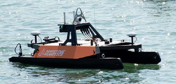
The Otter: Seabed Mapping Vessel
The Otter is a robust catamaran ideal for seabed mapping and monitoring of sheltered waters.
About the Company
Maritime Robotics is a leading provider of autonomous and unmanned vehicle systems for marine data acquisition. The company has over a decade of experience in developing innovative solutions for ocean mapping, monitoring, and research. Maritime Robotics works closely with industry leaders, governments, and research institutions worldwide.
About the Test Facility
Maritime Robotics portfolio includes Unmanned Surface Vehicles (USVs), autonomous navigation systems, and remote sensing tools designed to reduce risk, improve efficiency, and lower the environmental footprint in marine operations. The Otter is an Unmanned Surface Vehicle (USV) designed for efficient seabed mapping and monitoring in sheltered waters. Its compact catamaran design ensures stability and ease of deployment.
Use Cases
The Otter is ideal for:
- Conducting bathymetric surveys and environmental monitoring in confined aquatic environments such as small lakes, canals, rivers, ponds, and harbor areas.
- Efficient data collection
Technical Specifications
- Design: Catamaran hull for enhanced stability
- Control System: Operated via Maritime Robotics' Vehicle Control Station (VCS) or a mobile phone app. The VCS offers various control modes, including course and speed control, heading control, and waypoint navigation.
- Sensor Integration: Capable of carrying a variety of customer-defined sensors for comprehensive seabed and environmental mapping.
- Data Monitoring: Real-time monitoring of sensor data quality and performance through the VCS.
- Dimensions: 200 cm (length) x 108 cm (width) x 81.5 cm (height)
- Weight: 55 kg
- Portability: Components can be disassembled into parts weighing less than 20 kg, facilitating transport in a van or even on commercial airliners.
- Deployment: A single operator can launch the Otter from various locations, including jetties, lakesides, riversides, or beaches.
Operational Data
- Ease of Use: Designed for single-operator deployment without the need for specialized training.
- Portability: Lightweight components facilitate straightforward transportation and setup.
- Mission Planning: The VCS allows for easy planning of missions, including waypoint navigation and predefined survey patterns.
- Real-Time Feedback: Operators receive immediate data quality assessments and can adjust sensor parameters as needed during operations.
Safety Requirements
Contact Information